“Location, location, location,” has been the mantra of the real estate industry since its inception.
Successful real estate companies realize that opportunities come from detailed understanding and insights of local areas. Using advanced location-based services, or LBS technology, the collecting, integrating and analysis of location data gives real estate professionals that competitive edge when it comes to researching and showcasing properties to prospective buyers.
As one of the most lucrative industries worldwide, new technology is rapidly creating a new paradigm of GIS real estate usage where realtors can implement geographic searching, spatial analysis and 3D maps to drive sales and create unique, targeted marketing approaches for individual customers.
Implementing location technologies in real estate business can be extremely profitable, with the right tools and knowledge.
GIS real estate: geographic searching and spatial analysis with the help of LBS

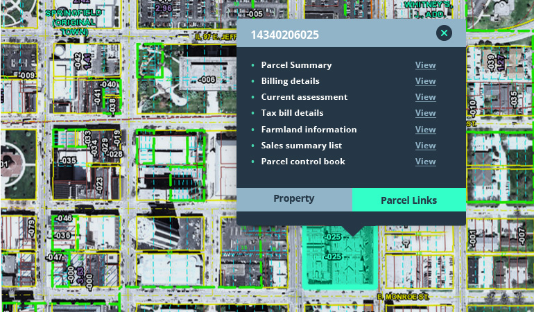
GIS, or geographic information systems are the foundations that property research, spatial analysis and market analysis for real estate are built on. By using this technology to collect, analyze and visualize geographic information on an interactive map, realtors can quickly identify the specific data required to understand local market opportunities and capitalize on them.
Location insights learned from analysis of the area, daily footfalls and neighborhood behaviors are essential for catering to your prospective buyer’s preferences. Highlighting the important characteristics of a property and matching them to your customers desires for their dream property, can often bridge the gap between closing a deal and needing more time to visit other properties.
Targeting your market efficiently

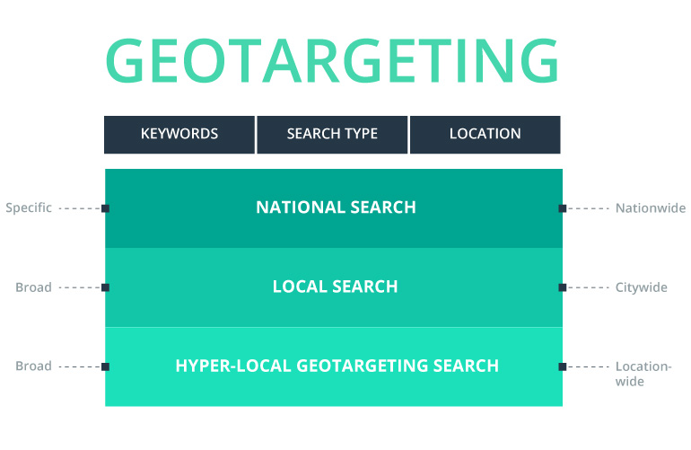
One of the many uses of LBS and GIS for facilities management allows real estate teams to identify where their target audiences live quickly and efficiently. In addition to in-depth market research to determine your perfect demographic, it’s easy to build custom territories and send marketing materials to neighborhoods with the highest density of your qualified target audience. This use of LBS technology can save potentially tens of thousands of dollars in marketing costs but will also give you an edge in producing profitable marketing campaigns that produce a measurable ROI.
Easy searches
While location-based searches can find data as simple as postal codes, this barely scratches the surface of the variety of information available. Customizing your search by locating where your qualified prospective buyers actually live, informs you with the correct data you need to deliver your targeted marketing campaign.
Searching nearby
Using this search function, you can visualize data based on distance. As a developer, it’s essential to have this data at your fingertips to make decisions about new projects. As a real estate agent, searching nearby is useful for targeting areas with more active listings and sales. Prospective buyers using this technology can easily find their dream home. Searches by location and square footage are all possible. By quickly adapting to changing market trends and behaviors, anyone looking for property who owns a mobile phone is a potential client.
Searching using map view
Map view searches are better for general areas, especially when you don’t know specific mileage. For example, if you wanted to do a search of the five boroughs in New York City. You may not know the radius of the five boroughs for purposes of a Nearby search, but you can center NYC and New Jersey inside your screen and conduct a map view search. This also works well for searching around suburbs or larger areas.
Searching Everywhere
While easy, nearby and map view searches are based on a specific geographic location, using the “Everywhere” option can also be used to deliver data without a specific geo-targeted search. This search will deliver up to 100,000 results and overlay them on a map that you can easily zoom in and out for more specific location data.
Customizable searches make it much easier to attract investors and determine your next profitable location to develop.
Visualizing data with 3D maps
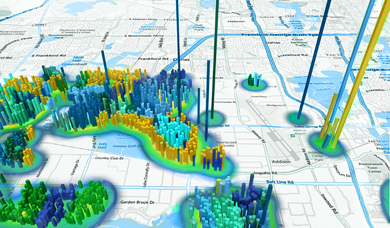
Neighborhood guides allow prospective buyers to visualize their new property, by showing everything from small homes to large scale, multi-title properties quickly and effectively. Seeing potential properties and their proximity to the nearest:
- schools,
- shops,
- restaurants,
- public transport,
- pathways
gives immediate context of the area to the buyer and simply shows everything a buyer takes into consideration before purchasing.
Users of these guides can also use advanced searches based on the number of rooms, bedrooms and even the amenities a particular property has.
Competitive insights

LBS technology can be equally as effective for monitoring competitor’s portfolios, sales and even consumer foot traffic patterns and loyalty levels. Advances in big data analysis have made it easy to:
- source new property listings;
- keep track of property price changes in real time;
- know when, where, through which agency and for what price a property sells;
- compare portfolios of real estate agencies in each area.
Routing for real estate showcases
One of the most lucrative ways to sell a lot of properties fast is to hold a real estate showcase or a “parade of homes.”
LBS technology and mapping real estate will save hours developing and planning out the best, and most effective route for prospective buyers to take. Using a combination of geocoding and neighborhood guides, you can take prospective buyers on a journey passing points of interest to get them to visualize living in the area. Take them on routes past schools, shopping areas, health clubs, grocery stores and even highlight the proximity of golf courses, country clubs and other places of interest.
Imagine the possibilities
As the Real Estate industry becomes more advanced and data-driven, location data has become the driving force behind the latest trends. Realtors and agencies must now adapt by improving the buying experience with customized data, showcases, routes and other information, or lose out on lucrative business.
With such a variety of ways LBS technology and GIS for facilities management can be used to catapult your Real Estate business into the 21st Century, the only question remains…. Why haven’t you started using LBS already?
Bring your Real Estate business to the next level by implementing Location Based Services for your customers. Contact Intellias to find out how.