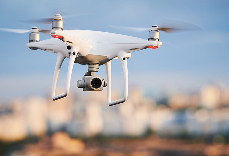
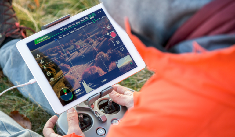
Drones are hovering into multiple industries, and drones for insurance inspections are no exception. Insurance companies already employ 17% of all commercial drones, and more drones will fill the skies in the next couple of years. PwC estimates that drone-powered solutions have an addressable market of $6.8 billion. So how are drones affecting the insurance industry?
What you’ll learn in this post:
1. How insurers are using drones or may use drones
- Deploying drones for insurance inspections
- Accelerating claim adjudication for homeowners and drivers
- Risk monitoring
- Gathering more data
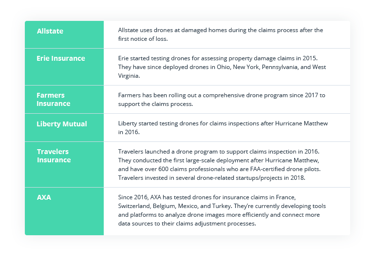
- Current uses of drones by large insurance companies
2. Benefits of using drones
3. Disadvantages and challenges of using drones for insurance inspections
4. Intellias’ take on using drones in the insurance industry
How insurers are using drones or may use drones
Drones present companies in the insurance industry with a revolutionary way of collecting data faster and more accurately.
Source: Accenture – How insurers are using drones right now
Accessing certain sites from the air can be more responsible from an environmental and human risk perspective. Drones for insurance inspections can reduce risks associated with inspecting severely damaged areas, contaminated sites, and hard-to-access premises.
Below are just a few ways that insurance companies already benefit or might benefit from drones for insurance claims.
Using drones for insurance inspections reduces time for damage assessment after natural disasters
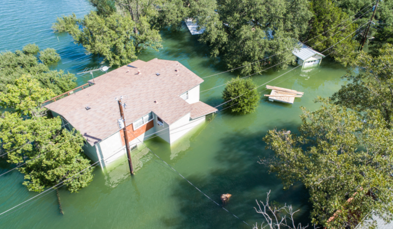
When a disaster hits, there’s no time to waste. Damage assessments must be done rapidly to ensure timely payouts for the affected people. However, accessing the disaster area may be downright dangerous for adjusters. Even when the situation stabilizes, civil authorities may still pose restrictions on entering areas. So thousands of claims are placed on hold, resulting in business downtime and mounting dissatisfaction among customers.
Drones can enter premises and zoom in on affected areas, capturing first-hand data without disturbing the scene. Your team can remain at a safe distance and review the transmitted video and photos in real time to assess the impact. And with advanced GIS solutions that rely on timely data to develop flight routes, if the weather conditions worsen, your UAV can return to safety fast and notify on-ground personnel.
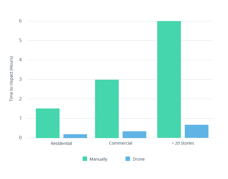
Using drones in insurance industry dramatically reduces the time for processing claims – a crucial factor for people whose properties have been severely damaged from hurricanes and other natural disasters.
A drone can help a claims adjuster process three houses in an hour. Without a drone, an adjuster could process only about three houses in a day.
After Hurricane Irma, 300 high-rise buildings were inspected by GFA Generali drone flying insurance. The process took just 10 days, whereas a ground crew of the same size would have needed months.
Drones can be used for proactive risk monitoring
Drones for insurance claims can be dispatched to monitor disaster-prone areas and gather data for giving more accurate quotes to residents. By partnering with governments, insurance companies can also alert residents about risks and help them minimize losses.
On a more granular level, drones for insurance inspections equipped with infrared cameras have proven effective at detecting water and air leaks – a complicated and time-consuming process for adjusters. Using drones for this purpose can boost the efficiency of your staff by 40 to 50 percent.
Accelerated claims adjudication for homeowners and drivers
Insurers were still relegated to getting property and roof data through archaic inspection processes that involved drive-by inspections, climbing ladders and manually inspecting roofs, or renting expensive machinery like cherry pickers to assess churches and multi-level structures.
The scenario described above is painfully common. Inefficient data gathering remains a pressing problem. It’s time for the insurance industry to ditch cameras on poles if they want to remain competitive.
According to a JD Power Study, a homeowner’s cycle time for a claim is the single most important factor in their satisfaction with an insurer. Long wait times mean that you’re losing business to a faster competitor.
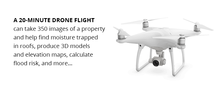
Using built-in sensors and cameras, drones for insurance claims can capture details such as moisture trapped in roofs, determine flood risks based on property elevation, and so on. Pictures and video streams can be transformed into 3D models, offering you a comprehensive view of a property.
Drones for insurance claims adjusters are a new necessary tool of the trade, as they enable better decision-making and eliminate guesstimation. Drones can also be used to eliminate false claims and disputes with customers who submit claims for existing damage.
Auto insurers should also look into drones. Instead of having boots on the ground, you can quickly dispatch a drone to investigate a claim filed by a customer. This can speed up claims settlement and improve the customer experience.
Drones can equip insurance companies with better data for analysis
Gathering comprehensive first-hand data is crucial to determine responsibility for an accident. Drones offer a safe and fast way of accessing damage. On-site information can be further enriched with additional location data –weather, road conditions, etc. – to create advanced site maps.
Emilien Rose, founder of Dronotec, a start-up specializing in drone inspection for insurance companies, shares how drone-powered mapping recently helped him. Last year, a major wildfire destroyed over 80 small housing units at a vacation destination in France.
Apart from collecting on-site data to create a detailed plan with measurements, Rose’s team also analyzed meteorological data about wind direction on the day of the fire. After testing several theories, the team determined that the fire had started in or around one of the housing units in the area. These units were not on their customer’s property. The insurance company was able to provide proof that their customer wasn’t responsible for the fire and thus deny a six-figure responsibility claim.
Additional use cases of drones among large insurance companies
What are the benefits of using drones for insurers?
With additional clarity from above, insurers can save up to $7 billion per year.
Better data collection, powered by unmanned aerial vehicles, leads to dramatically faster claims processing, better efficiency, and higher profits. Insurance companies using drones have already reported the following benefits.
Better transaction processing. It’s time to leave that ladder at home. Your employees (and customers) shouldn’t put themselves at risk during hands-on inspections at construction sites and other hazardous places. And those inspections shouldn’t take months.
Insurance companies that use drones receive the information they need 10 times faster than those relying on traditional methods. The costs of gathering that information are also lower.
Efficiency gains using drones
Source: CB Insights – The insurance industry is poised to lead the way in drone adoption
Increased efficiency and cost reduction. In the oil industry, drones have proven to be 85% faster and cheaper than human-led inspections. A drone can investigate 150 miles of pipeline per day, just like a helicopter crew. Yet drone services will cost you less than $2,500 per hour.
With drones, you can also reduce the number of field adjusters and deploy highly skilled people only when truly necessary.
Less fraud. In the automotive industry, insurers lose at least $29 billion annually in premium leakage. Common sources of losses include:
- $10 billion – unrecognized drivers
- $5.4 billion – underestimated mileage
- $3.4 billion – violations/accidents
- $2.9 billion – false garaging to lower premiums
Drones, powered with location-based services, can help insurers collect more accurate data and patch up those leaks.
Improved employee safety. Drones can access dangerous areas during inspections, minimizing the risk of harm to your employees. Think of this as an insurance for the insurer.
Current disadvantages of using drones for the insurance industry
Image source: StockSnap
Adopting disruptive technologies of drones in insurance industry always carries a certain amount of regulatory and business risk. For drones to become part of business as usual, the insurance industry will have to address a few drone-related issues.
Aviation regulations. The current FAA rules are rather straightforward, allowing commercial drones to stay in the air during the daytime. They can fly no higher than 400 feet above the ground at a maximum speed of 100 miles per hour. As a rule, a drone must remain in the visual line of sight at all times. These requirements may somewhat limit an insurer’s ability to use drones for large-scale inspections. But recent waivers now allow limited operations beyond visual line of sight. We should expect more progressive rulings for UAVs issued by regulators around the world.
Additional UAV regulations currently under discussion in the US
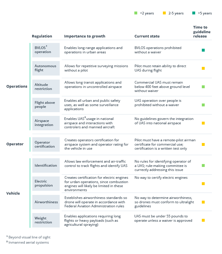
Source: McKinsey – Commercial drones are here: The future of unmanned aerial systems
Privacy. Trespassing and operating below navigable airspace can cause legal problems for insurers. That’s why developing rich navigational maps with real-time data is crucial to protect your company against common-law nuisance claims. Additionally, don’t forget to obtain permission from insured individuals before conducting a risk assessment of their property. Otherwise, you may get into legal trouble.
Casualties and liability. Drone crashes, injuries, and casualties have been widely publicized. After last year’s drone incident at Gatwick airport, the general public has mixed feelings toward the safety of UAVs. Insurers will have to carefully assess the potential damage drone inspections can cause and be prepared to address possible negligence and liability claims.
Corrupted technology. 63% of drone crashes occur due to technological glitches, not human error. Loss of communication between a UAV and the operator is the most common problem. To reduce these risks, carefully choose both hardware and software services. Partner with professional and experienced developers who have deep industry knowledge.
Data leakage and security. Sensitive data can be lost due to a crash or equipment malfunction. Drones, which transmit data in real time, are also exposed to cyber attacks. The blockchain is one option for managing such sensitive data exchanges, and is now in the spotlight for many businesses.
IBM has recently filed a patent showcasing a new blockchain-based solution that can be used for securely transmitting data about a drone’s location, flight behavior, and proximity to restricted zones, plus additional analytics related to its operations. The patent also notes that IBM plans to use smart contracts for delivering additional data to the system.
Smart contracts are a progressive method of transmitting information and ensuring that it’s safely recorded on a decentralized ledger. They allow you to further enhance risk assessment and premium computations by eliminating data inconsistencies and the possibility of errors.
The good news is that all the disadvantages addressed above are manageable. Especially when you plan for them in advance.
Intellias’ take on using drones in the insurance industry
We believe that drones will rewrite the insurance industry’s standard operating procedures. Drone flying insurance regulations are changing. New technologies (such as autonomous avoidance systems) will reduce the liability risks of using drones.
Tap into our vast experience in geospatial analysis and location-based services to further minimize the operational risks of your drones. For the past five years, our team has been working on an advanced drone data platform for safe navigation.
This platform features enriched 2D maps for aviation, updated in real time with new data about no-fly zones, powerlines, weather, temporary flight restrictions, and additional insights. The platform includes several major APIs and SDKs that could be used in your product:
- API for defining the safety of flying a drone to a specific coordinate
- API for geometry analysis of all local low-altitude airspace advisories
- API for identifying drones and authenticating drone operators
- API for running a search by drone metadata, manufacturer, and model
Our client’s platform is already used by 80% of drone operators in the USA alone. And it’s been localized for aviation regulations in the UK, Japan, New Zealand, and Canada.
Are you ready to leverage insurance software development services?
Contact us to receive more information about drone navigation solutions and location-based services for custom InsurTech products.