Recent advances in GIS in agriculture are set to remove many of the industry’s challenges. Agribusiness has traditionally had difficulty managing the vast amounts of spatial data. The effective presentation of the data has also proven challenging. This is a particular stumbling block since Geographic Information System (GIS) data needs to be understandable to the decision-makers — farmers, suppliers, investors, and insurers.
The latest GIS software lets agribusinesses organize essential information across datasets, present it visually, and use it for forecasting. It can help expand operations, prevent resource waste, and provide more accurate financial predictions.
In this article we’ll explore types of geospatial technology and GIS applications in agriculture and related industries. We’ll also show how our GIS solutions can help you achieve sustainable results.
Geographic Information System (GIS) is a technology that collects, analyzes, and presents spatial data. This includes surface, soil type, land covers, elevation, and weather conditions.
GIS in agriculture also provides data analysis and visualization capabilities. Modern software can help you assess your resources, optimize planting, fertilizing, and harvesting procedures, forecast yields, and predict natural risks. It essentially lets farming businesses get the most out of each acre.
How agricultural businesses collect and use GIS data

Agricultural companies rely on geoinformatics in agriculture — the use of field mapping tools, remote sensing devices, and open databases for agricultural analysis. These are some of the technologies and data sources used for geospatial analysis:
Aerial imagery?
Satellites, aircraft, and drones deliver high-resolution and multispectral images of the Earth’s surface. In particular, satellites provide synthetic aperture radar (SAR) images that provide detailed spatial information despite visual obstructions like clouds, fog, and darkness.
GPS data
The Global Positioning System (GPS) is a satellite-based navigation system that provides geolocation and navigation information. GPS can help delineate field boundaries, assess soil properties, chart crop yields, and track livestock.
Remote sensing devices
When affixed to aerial and ground vehicles, remote sensing devices capture different layers of information. These can include thermal, radar, lidar, and multispectral data. One example includes thermal infrared radiation (TIR) sensors that analyze surface temperatures by interpreting wavelengths emitted by vegetation.
Monitoring tools
Remote sensors can capture the physical and chemical properties of objects. This includes remote monitoring tools that provide real-time data about livestock health, soil fertilization, and likelihood of infestation.
Public databases
Public agricultural databases house different types of farming-related information. This includes historical data about crop yields, terrain intricacies, weather patterns, or soil composition. Databases can also include information about broader socio-economic and environmental factors that affect agriculture.
Variable-rate technology
Variable-rate technology (VRT) helps apply different farm inputs within a field without manually changing settings. You can integrate VRT with GIS data and real-time sensor feedback to regulate water irrigation, chemical mixes, and other processes.
Autonomous machinery
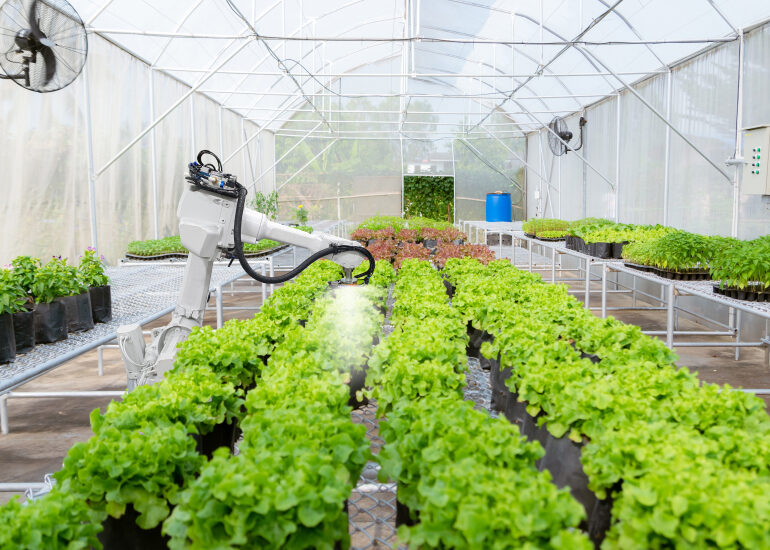
GIS data can help guide drones and other robotic technologies to perform planting, weeding, harvesting, and other tasks at optimal efficiency. When equipped with sensors, unmanned drones can gather information about the environment and crop health.
All data should be converted into a compatible format for your GIS software. Additionally, all spatial imagery should fit together on the same scale. This often means the datasets must be digitized, georeferenced, clipped, and merged.
The result is an interactive field map featuring crop position and health status, topography, soil type, fertilization, and other critical details. Now, let’s see how companies use this information and technology in agricultural processes.
Application of GIS in agriculture
Modern GIS technologies provide a new dimension of insight into processes and resources. In this section, we’ll discuss some of its key uses for different aspects of the agricultural business.
Crop yield prediction
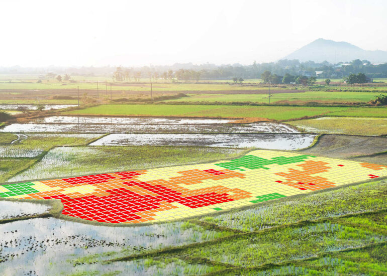
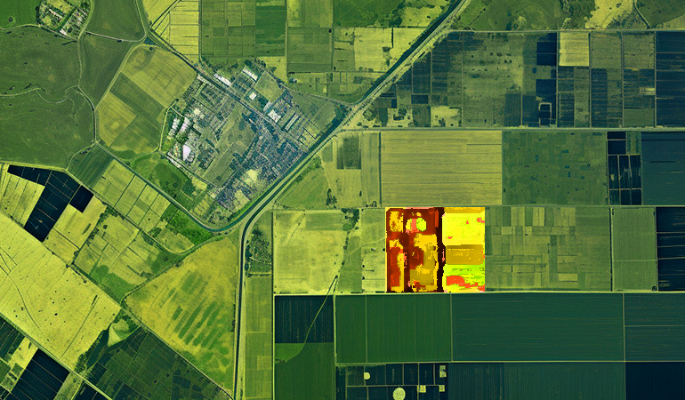
Companies can forecast crop production by integrating AI technologies and big data in agriculture. For example, weather stations, soil tests, and crop sensors can help estimate crop performance. Additionally, using GIS data for spatial analysis and correlation lets you identify factors that affect crop yield (such as weed infestation or nutrient deficiency).
One of the most profound techniques is Convolutional Neural Networks (CNNs or ConvNets). A ConvNet is a deep learning algorithm that assesses crop yield potential, gaps, and soil requirements via images present in the productivity patterns. This lets farmers proactively adjust irrigation and fertilizer applications to maximize yield potential.
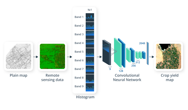
Source: Sustainability and Artificial Intelligence Lab, Stanford University
Intellias has developed a unified farm management system that integrates GIS precision analysis and historical data to optimize crop cultivation. It provides a comprehensive overview of farming activities and potential threats.
Crop health monitoring
Companies can check crop health using GIS data from satellite images, thermal sensors, and multispectral cameras. This data helps assess environmental conditions across the field, such as chlorophyll content, water stress, leaf area index, and vegetation indices.
A more sophisticated approach uses imaging sensors on satellites and aerial vehicles to check the temperature of crops. When the temperature is above normal, this might indicate disease, infestation, or insufficient irrigation.
We have also developed comprehensive crop management software for sustainable farming. It gauges field conditions, identifies environmental risks, and subsequently provides actionable advice to promote eco-friendly practices. The software also meets the standards and certifications of organic farming and carbon footprint reduction.
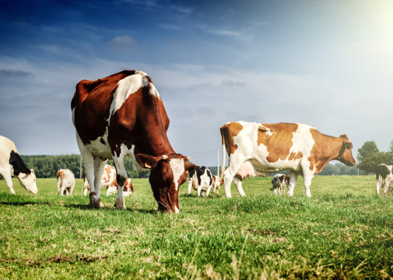
Livestock monitoring
Farmers use GIS software to monitor animals’ health, fertility, and nutrition levels. You can equip cattle with trackers typically attached to their ears or necks. These trackers can be connected to GPS systems, digital scales, and other devices.
For instance, when beef cattle step onto these scales, the system reads the tracker ID and instantly updates the weight of that particular animal in the database. You can also monitor the body temperature and activity levels. Then, the system will automatically notify you of any alarming changes in the animal’s health.
Other applications of GIS technology in agriculture include animal location tracking to prevent cattle from wandering off and deter stock theft. Another use case is predicting wildlife encounters. By using GPS collars, drones, or satellites, the system can alert farmers and wildlife managers to the proximity of wolves.
Insect and pest control
Insects and pests can wreak havoc on crops. Leveraging GIS technology with on-ground cameras and drones helps identify infested locations. Yet high-resolution images alone might not be enough to detect early signs of infestation.
However, neural networks, image processing, and deep learning algorithms combined can discern potential infestations. This usually means training the model on historical images of infested areas. After that, your GIS software can use land images and on-site visuals to accurately identify an infestation, its density, and the type of insect.
It’s also possible to identify potential infestations via sensors that monitor crop temperature. For example, plants tend to warm up due to reduced water or nutrition during an infestation.
Irrigation control
Geoinformatics and GIS software can help ensure that each crop receives the right balance of water and chemical ingredients. Collecting sensor data can provide real-time insights into soil moisture, water stress, and evapotranspiration levels.
Pairing AI-based tools with high-resolution satellite images and weather station data helps predict water shortages. Meanwhile, pairing images with water delivery systems enables farmers to optimize their irrigation schemes to increase yield quality.
Flooding, erosion, and drought control
Geospatial technology in agriculture helps prevent and mitigate natural disasters. For example, you can identify flood-prone areas with flood inventory mapping techniques, field surveys, and data about local natural phenomena.
Companies can pair Universal Soil Loss Equation (USLE) with GIS and remote sensing to identify areas susceptible to erosion. You can apply spectral analysis to satellite images to obtain USLE factors and validate them with field observations. This can help you create a map that shows the soil deterioration level across a field.
Intellias has rolled out weather prediction and disaster management software that connects to stations via GSM technology and satellites. This ensures comprehensible insights into environmental threats in inaccessible regions.
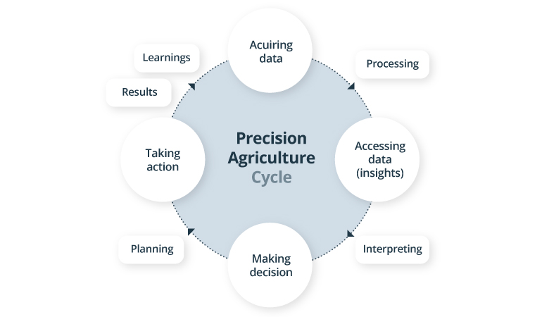
Precision agriculture
Utilizing GIS data helps illuminate the land’s contours, the regions prone to water accumulation during heavy rainfall, and the areas bathed in maximum sunlight. This can guide you on where to plant specific crops to optimize their growth.
Spatial data helps harvesting practices. For example, it enables contour (terrace) farming that involves planting and plowing along the slope contours. It also makes it easier to alternate between rows to prevent erosion or divert rainwater in specific areas to protect the soil.
GIS solutions and sensors can enhance resource efficiency. They can help farmers dispense seeds, fertilizers, nutrients, and pesticides precisely where and when they are needed to help save costs.
Farming automation
GIS in farming can enable smart machines to operate in the field. You can create task (application) maps to guide seeding machines, intelligent irrigation systems, driverless harvesters, and weed-eliminator robots.
Here’s an example of how GIS solutions for agriculture can work. Once a GIS system detects weed infestation, it assigns a “Weeding needed” label. The weed elimination robot reads the tag and places this area on its list of tasks.
Task maps can also help workers do their job more efficiently. For example, a visual dashboard can contain real-time information on where to apply fertilizers, nutrients, or pesticides.
Use of GIS in agriculture across businesses
We often associate agriculture strictly with farming. But it goes far beyond that. Many businesses directly and indirectly related to agriculture use GIS to optimize processes and improve decision-making.
Insurance companies
Agricultural insurers must assess a wide range of risks, from geographic and agronomic to climatic and loan repayment. GIS data from satellite imagery and sensors can ease some of these tasks.
GIS technologies allow insurers to calculate the vegetation index (NDVI) to monitor crop growth and other crucial indices. Spatial data and AI analytics can estimate the probability of loss and damage. With the help of geographic information systems and visualization software, companies can also assess crop health without physical visits to villages.
Banks and loan companies
GIS data can help assess the financial potential and risks associated with agribusinesses. By utilizing spatial data related to land use, crop yields, market accessibility, and environmental metrics, they can effectively gauge the creditworthiness of their clientele.
GIS simplifies compliance with regulations related to environmental, social, and governance (ESG) factors. For example, spatial data can provide a more accurate assessment of a carbon footprint, water usage, and land degradation.
IT & telecom companies
IT organizations provide GIS web platforms and applications for the agricultural domain. Microsoft’s FarmBeats platform capitalizes on AI and IoT to present farmers with insights on topics such as soil health, water usage, and crop management. Another example is IBM’s AI-based Watson Decision Platform to help optimize plowing, planting, and harvesting.
On top of that, access to geoinformatics helps telecom companies identify optimal locations for installing towers, antennas, and other infrastructure. This provides farmers with reliable connectivity to access GIS platforms.
Input suppliers
Input suppliers can use spatial data to customize their products and services for different regions in agriculture. GIS helps them to analyze soil properties, crop types, farmer preferences, and market demand to align their offerings with local farmer’s needs.
Geospatial technology and GPS also help agribusinesses optimize crop delivery. Suppliers can reduce costs and time on delivery by considering factors such as road conditions and weather patterns. Field mapping also improves transportation networks between facilities, roads, warehouses, and terminals.
Governments and NGOs
GIS technology allows government entities and non-government organizations to shape agricultural policies. It helps measure and monitor the environmental impact of farming activities in order to enforce and comply with environmental standards. To illustrate, the International Food Policy Research Institute (IFPRI) uses GIS to research agricultural innovations, produce publications, and inform policymakers.
GIS also helps to disseminate agricultural information. For example, New York State has a GIS clearinghouse that offers diverse data on agriculture. The USDA’s CropScape is a free online tool that shows crop types and locations across the country. In addition, The Landsat 8 project collects satellite data that can be used to diagnose plants.
Agricultural consultants
Consultancy agencies use geospatial technologies and geoinformatics to provide advice to agribusinesses. They draw heavily from spatial data about certain territories, analyzing elements like water availability, pest occurrences, and the implications of climate change.
The GIS software helps consultants communicate their findings to farmers and agribusinesses. They convert spatial data into easily digestible interactive maps and charts to back up their advice.
Educational facilities
GIS data helps educational institutions to share knowledge about agricultural practices. Teachers and students can use GIS data to visualize and analyze complex agricultural systems, spanning from crop production and soil management to pest control and harvesting techniques.
Organizations use geoinformatics and GIS technologies to collect data, apply advanced methods and models, and generate new solutions. Educational facilities also use this technology to share their findings with other educators, agricultural businesses, and NGOs.
The role of digital twins in agriculture
A digital twin is a digital model of a real-world agricultural system, including fields, crops, livestock, and infrastructure. This technology uses satellite imagery, meteorological predictions, sensors, and public databases for simulations.
The key capabilities of digital twin technology for agriculture include:
- Data centralization. Digital twins seamlessly integrate information from various sources, giving stakeholders a comprehensive view of their agricultural ecosystem from a single platform.
- Real-time monitoring. Data from real-world systems allows agribusinesses to monitor crop growth, soil moisture, field temperature, and other immediate information.
- Process simulations. Digital twins allow farmers to simulate how different inputs (like pesticides, irrigation levels, and harvesting practices) impact their business. This helps farmers plan and prepare for various situations, reducing uncertainties and risks.
- Predictive modeling. By integrating digital twins with prediction models and algorithms, farmers can anticipate future events. So, they can prepare for changes in climate, demand shifts, or environmental hazards.
With digital twins, agribusinesses can strengthen their sustainability, optimize their decisions, and experiment without financial or environmental risks.
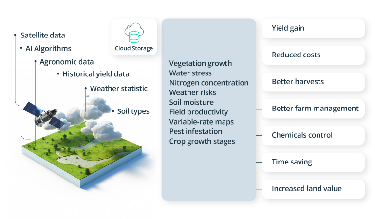
GIS for agriculture sustainability
Integrating and managing vast amounts of data from scattered sources is one of the key challenges in agriculture. This lack of uniformity often leads to knowledge gaps. The result is process inefficiencies and unnecessary risk.
Agriculture can become more sustainable by centralizing all GIS data and sensory information in a single platform. However, not all digital solutions are equally effective. Many platforms that market themselves as universal solutions ignore the unique conditions of different types of farms.
That’s why Intellias has partnered with Grand Farm to help agribusinesses consolidate diverse data sets, both public and private. Our Data Hub provides a comprehensive storage system for GIS and agriculture data while addressing the interoperability challenges and adhering to data security standards.
Our platform is optimized for research, automation, and simulation. Users can search and filter data according to their needs. For example, you can quickly find images for pest outbreaks in 2022. We also added a rating system to help users avoid subpar datasets.
The Data Hub also enables users to visually assess their resources, access detailed soil reports, and understand the capabilities of various soil types. They can also integrate public algorithms to enhance their analysis. The information in the platform empowers organizations to create digital twins for advanced simulations.
The future importance of GIS in agriculture
It’s safe to say that the agricultural sector depends on GIS technologies. By combining GIS with sensors, autonomous machines, and AI-powered analytics, organizations can predict crop yields, detect soil erosion, and assess environmental threats with remarkable accuracy.
Investing in GIS technology is a wise move for the future. GIS applications in agriculture are becoming efficient at spatial data monitoring, simulations, interactive maps, and visual presentation. This helps agribusiness and related industries improve productivity, profitability, and sustainability.
At Intellias, we have expertise in agricultural software development and GIS services. We can capture geospatial data, develop 3D landscape models, or build custom farm management systems. Contact us to see how we can help you transform your ideas into solutions or streamline your agricultural operations.