What role do drones play in modern agriculture? It largely depends on whom you ask.
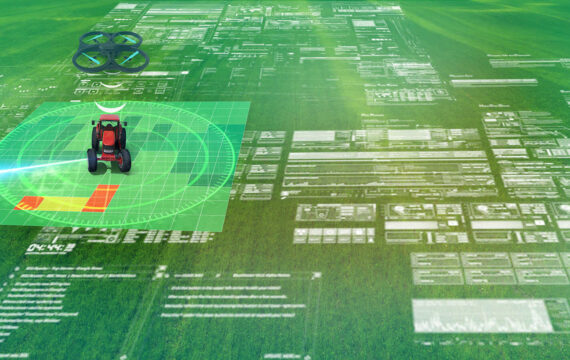
AgriTech providers would showcase features of agricultural drone technology like cameras, thermal sensors for creating field maps, and the amount of valuable data drones can collect.
Farmers see agricultural drones as an additional expense and a source of unstructured data they don’t know how to act on. And they certainly are looking for ways to return their investment in drones.
The recent “Drones in Agriculture: Lessons From The Field” webinar by DroneDeploy on drone use for agriculture addressed the most significant challenges farmers and AgriTech providers want to overcome with drones this year. In a survey conducted during the webinar, 56% of respondents chose interpreting drone data to make crop decisions as the challenge they most wanted to address.
In this article, we’ll focus on applications of agricultural drone technology that are beneficial for both farmers and AgriTech providers and see how robust integrations can help farmers interpret data from agricultural drones to make decisions about crops.
What you’ll find inside:
- What farmers want from agricultural drones
- The most beneficial applications of UAV crop monitoring
- Ways to interpret data from agricultural drones to make crop decisions
What do farmers want from agricultural drones?
Collaboration with farmers is key for AgriTech providers. Understanding farming operations, differences in approaches to various crops, and farmers’ expectations from technology can help AgriTech companies keep their offerings tied to farmers’ needs.
What farmers get now is a large amount of data they need to sort out, which requires a lot of time and effort. What they want are recommendations based on field data — maybe without need to directly interact with this data at all. Going further, farmers may want technology to automatically respond to data insights with only minor intervention from the farmer’s side. All in all, farmers would not mind pushing a button and seeing the farm work automatically.
This level of automation is probably far off, but practical cases of interpreting data into actionable insights are already around.
What farmers need from agricultural drones:

The most beneficial applications of UAV crop monitoring
Farmers are striving for insights, not raw data. If farmers need to take an additional 5 to 10 steps after collecting data to see its value, they’ll choose not to do so. To provide these insights, AgriTech companies should process data right away and integrate agricultural drone technology with crop management systems, drone mapping software, automated machinery, and even payment systems to create a borderless ecosystem of agricultural technologies. Later, farmers may find a correlation between drone usage and return on investment (ROI) on this technology.
ROI really doesn’t become attractive unless you start thinking about the unmanned systems as just a part of a solution, not the solution in and of itself. It takes an investment of time and money from the growers and from the vendors to see how the info gathered from a drone can connect to other things that are happening on their farm. Growers need that info to provide context and create a correlation, and then you get to cause and effect.
Interpreting drone data into actionable insights:

After data is processed by an AgriTech provider’s solution, a farmer can apply insights to field operations. The most important part is to free farmers from manually inputting data into other systems or forcing them to find clues all by themselves. Machine learning and AI algorithms play a crucial role in automating the response to data from UAVs for agriculture. After drawing insights on one field and one type of crop in certain conditions, an AI system can recognize patterns and scale analytics to other fields, acquiring more and more data to learn from.
Drone data can be interpreted more meaningfully when the data is accurate and relevant to the recommendations the farmer wants. Data accuracy can be achieved by applying advanced technologies like IoT connectivity, AI analytics, and cloud computing. These technologies can even be integrated into farm management systems to provide farmers with advice on profitable crop management all season long.
Putting drone data to use

Ways to interpret agricultural drone data for crop decisions
Figuring out the specific approach to take on a particular crop or field allows farmers to understand the value of UAV technology for agriculture. For this, let’s look at data collected by drones and see what this data means to farmers and what recommendations they can get out of it.
Light reflection
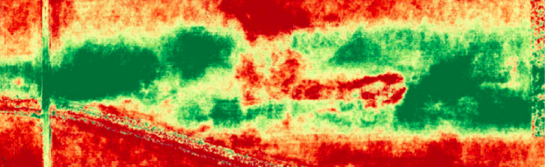
Hyperspectral cameras, normalized difference vegetation index (NDVI) algorithms, and knowledge of crop science can be used to transform images of light reflected by plants into actionable insights. Put simply, plants reflect spectral light differently, which is why healthy crops are green while damaged ones are red in the image above. Moreover, monitoring systems can tag many more colors to different conditions like soil moisture, crop health, unmatured weeds, and mature crops.
An AI-based system behind cameras can recognize patterns by comparing captured images to associate particular colors and locations with crop conditions. To avoid overwhelming farmers, AI-based systems may suggest just a few options to choose from. These could be starting to irrigate, fixing drainage, adding pesticides, or sending harvesters to the fields. Farmers can also use AI-based systems to compare ROI before and after precise mapping of areas and see the difference drones make.
Monitoring trial plots
Data collection and data analytics can be distributed between interconnected apps. While experimenting with active ingredients, farmers can divide their fields into trial plots to investigate the performance of crops under certain conditions. UAV crop monitoring eliminates manual collection of data on trial plots by capturing real-time images and overlaying them onto field maps as an active layer using drone mapping software. Collected data can be matched with specific criteria and assessed by a third-party application with a large database. All the farmer sees is a user-friendly dashboard with results of one particular ingredient on crops. This indicates that growth of a crop should be scaled under the chosen condition. Farmers may also observe the failure of an experiment to change nutrients or crops. By interpreting drone data, farmers can make wise choices.
Recommendation maps
Displaying field insights on interactive maps is another valuable use case for drones in agriculture to minimize the critical response time for nutrition management. Detecting a nutrition deficit in certain areas with thermal maps can enable a prompt response and reduce crop stress. The time period to react to a nutrition deficit without damaging a crop is narrow, so farmers definitely don’t have time for manual data processing.
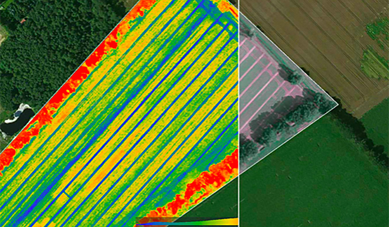
Agricultural drone images can show the variability of nutrients in fields throughout the season based on different temperatures. Areas with enough natural nutrients, the optimal level of nitrogen, or a lack of nutrients can all be marked so farmers easily recognize problematic spots. The same thermal maps can recognize areas with underground water (where the temperature is low) for smart nitrogen management. Water streams move nutrients across fields, so algorithms can calculate the projected level of nitrogen that will be delivered to an area by water flows. Other applications of agricultural drone images include detecting heat stress and irrigation levels, which can help farmers prepare for upcoming seasons or save resources.
Industry-agnostic algorithms
Applying experience from other industries to farming operations seems like a good idea. The main drawback of niche agricultural solutions can be their lack of computing power, while cross-industry platforms may provide enough resources to process any data regardless of application. Deep learning algorithms, which have already established themselves recognizing patterns of object behavior in hard-to-predict environments like cities, can learn new and easier environments much faster.
For farmers, this means faster insights and scalable options to take actions on different fields without spending seasons collecting new data. In the long-term perspective, such cross-industry algorithms could be used across the world with a possibility to adapt to various environments.
Final thoughts
An old saying of farmers is that you should go dirty your boots to find out what’s going on at your farm. AI-powered agricultural drone data collection and analytics can show farmers where and when to dirty their boots. On the other hand, AgriTech developers should also have an intimate understanding of farming operations. This is not always possible, but farmers would appreciate developers sharing their field to watch drones launch and giving advice on how to interpret all the data they will return with days later.
Apart from in-field experience, for AgriTech companies it’s critical to find a reliable software development partner who can accelerate development after gathering valuable feedback from farmers. Get in touch with Intellias agriculture R&D experts to respond to farmers’ needs, introduce agile workflow practices, and outpace your competitors with high-quality software for applying location sensors in agriculture, oversized transportation optimization software, smart irrigation solutions, and agricultural drone data processing services.